![](/images/other/stat-length.png)
![Tocht Andere activiteiten La Brillaz - Onnens-Corjolens.Lovens - Photo](https://media.geolcdn.com/t/1900/400/ext.pjpeg?maxdim=2&url=https%3A%2F%2Fstatic1.geolcdn.com%2Fsiteimages%2Fupload%2Ffiles%2F1545311037marcheuse_200dpi.jpg)
Onnens-Corjolens.Lovens
rene.esseiva
Gebruiker
![Lengte](/images/other/stat-length.png)
Lengte
7,6 km
![Max. hoogte](https://static1.geolcdn.com/siteimages/upload/files/1508320355ic_sort_altitude_max_24dp.png)
Max. hoogte
770 m
![Positief hoogteverschil](https://static1.geolcdn.com/siteimages/upload/files/1508320355ic_sort_den_pos_24dp.png)
Positief hoogteverschil
170 m
![Km-Effort](/images/other/stat-length.png)
Km-Effort
9,9 km
![Min. hoogte](https://static1.geolcdn.com/siteimages/upload/files/1508320355ic_sort_altitude_min_24dp.png)
Min. hoogte
654 m
![Negatief hoogteverschil](https://static1.geolcdn.com/siteimages/upload/files/1508320355ic_sort_den_neg_24dp.png)
Negatief hoogteverschil
168 m
![Boucle](https://static1.geolcdn.com/siteimages/upload/files/16400158638029165_repeat_loop_refresh_sync_direction_icon.png)
Boucle
Ja
Datum van aanmaak :
2015-09-11 00:00:00.0
Laatste wijziging :
2015-09-11 00:00:00.0
![Andere activiteiten](https://static1.geolcdn.com/sitytour/trail-icons/900.png)
2h23
Moeilijkheid : Gemakkelijk
![Scan deze QR-code om de tocht te openen in de SityTrail-applicatie](https://capi.geolives.com/qq0zvz2zws4bq2lad0pu/sitytour/trails/470706/qr.png?size=200)
Gratisgps-wandelapplicatie
Over ons
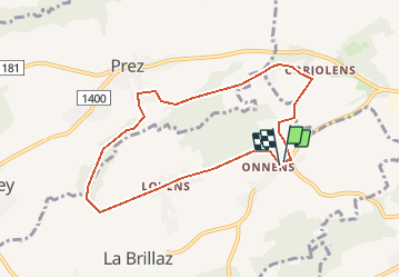
Tocht Andere activiteiten van 7,6 km beschikbaar op Fribourg/Freiburg, District de la Sarine, La Brillaz. Deze tocht wordt voorgesteld door rene.esseiva.
Beschrijving
Romont-ChénensFr. 3.00
Parking: à côté de l'Eglise d'OInnens,
Restaurant: Auberge du Chêne Chénens tél. 027 477 12 98
Curxiosité: hameau de Lovens, chapelle La Brillaz
Plaatsbepaling
Land:
Switzerland
Regio :
Fribourg/Freiburg
Departement/Provincie :
District de la Sarine
Gemeente :
La Brillaz
Locatie:
Unknown
Vertrek:(Dec)
Vertrek:(UTM)
350320 ; 5182096 (32T) N.
Opmerkingen
Wandeltochten in de omgeving
![Tocht Te voet Matran - Matran - Noréaz - Photo](https://media.geolcdn.com/t/375/260/7a2244db-87fb-4c17-aec0-e64a7984f7bf.jpeg&format=jpg&maxdim=2)
![Te voet Te voet](https://static1.geolcdn.com/sitytour/trail-icons/100.png)
Matran - Noréaz
Te voet
Gemakkelijk
Matran,
Fribourg/Freiburg,
District de la Sarine,
Switzerland
![](/images/other/stat-length.png)
5,9 km | 7,2 km-effort
1h 38min
![](https://static1.geolcdn.com/siteimages/upload/files/16400158638029165_repeat_loop_refresh_sync_direction_icon.png)
Neen
![Tocht Te voet Hauterive (FR) - Monterban - La Glâne - Photo](https://media.geolcdn.com/t/375/260/59928ce9-52b8-4f15-a475-7e090e4d372a.jpeg&format=jpg&maxdim=2)
![Te voet Te voet](https://static1.geolcdn.com/sitytour/trail-icons/100.png)
Monterban - La Glâne
Te voet
Gemakkelijk
Hauterive (FR),
Fribourg/Freiburg,
District de la Sarine,
Switzerland
![](/images/other/stat-length.png)
3,2 km | 3,7 km-effort
50min
![](https://static1.geolcdn.com/siteimages/upload/files/16400158638029165_repeat_loop_refresh_sync_direction_icon.png)
Neen
![Tocht Te voet Corminboeuf - Corminboeuf Village Suisse - Matran - Photo](https://media.geolcdn.com/t/375/260/7a2244db-87fb-4c17-aec0-e64a7984f7bf.jpeg&format=jpg&maxdim=2)
![Te voet Te voet](https://static1.geolcdn.com/sitytour/trail-icons/100.png)
Corminboeuf Village Suisse - Matran
Te voet
Gemakkelijk
Corminboeuf,
Fribourg/Freiburg,
District de la Sarine,
Switzerland
![](/images/other/stat-length.png)
3,2 km | 4,1 km-effort
55min
![](https://static1.geolcdn.com/siteimages/upload/files/16400158638029165_repeat_loop_refresh_sync_direction_icon.png)
Neen
![Tocht Te voet Corminboeuf - Circuit de Chésopelloz - Photo](https://media.geolcdn.com/t/375/260/ext.jpg?maxdim=2&url=https%3A%2F%2Fstatic1.geolcdn.com%2Fsiteimages%2Fupload%2Ffiles%2F1545311037marcheuse_200dpi.jpg)
![Te voet Te voet](https://static1.geolcdn.com/sitytour/trail-icons/100.png)
Circuit de Chésopelloz
Te voet
Gemakkelijk
Corminboeuf,
Fribourg/Freiburg,
District de la Sarine,
Switzerland
![](/images/other/stat-length.png)
9,7 km | 14,1 km-effort
3h 11min
![](https://static1.geolcdn.com/siteimages/upload/files/16400158638029165_repeat_loop_refresh_sync_direction_icon.png)
Ja
![Tocht Te voet Ponthaux - Nierlet-les-Bois Pré de Chêne - Corminboeuf Village Suisse - Photo](https://media.geolcdn.com/t/375/260/ext.jpg?maxdim=2&url=https%3A%2F%2Fstatic1.geolcdn.com%2Fsiteimages%2Fupload%2Ffiles%2F1545311037marcheuse_200dpi.jpg)
![Te voet Te voet](https://static1.geolcdn.com/sitytour/trail-icons/100.png)
Nierlet-les-Bois Pré de Chêne - Corminboeuf Village Suisse
Te voet
Gemakkelijk
Ponthaux,
Fribourg/Freiburg,
District de la Sarine,
Switzerland
![](/images/other/stat-length.png)
5,1 km | 7,4 km-effort
1h 40min
![](https://static1.geolcdn.com/siteimages/upload/files/16400158638029165_repeat_loop_refresh_sync_direction_icon.png)
Neen
![Tocht Te voet Belfaux - Circuit de Belfaux - Photo](https://media.geolcdn.com/t/375/260/ext.jpg?maxdim=2&url=https%3A%2F%2Fstatic1.geolcdn.com%2Fsiteimages%2Fupload%2Ffiles%2F1545311037marcheuse_200dpi.jpg)
![Te voet Te voet](https://static1.geolcdn.com/sitytour/trail-icons/100.png)
Circuit de Belfaux
Te voet
Gemakkelijk
Belfaux,
Fribourg/Freiburg,
District de la Sarine,
Switzerland
![](/images/other/stat-length.png)
6,6 km | 9,2 km-effort
2h 5min
![](https://static1.geolcdn.com/siteimages/upload/files/16400158638029165_repeat_loop_refresh_sync_direction_icon.png)
Ja
![Tocht Te voet Belfaux - Belfaux rte de Chésopelloz - Autafond - Photo](https://media.geolcdn.com/t/375/260/ext.jpg?maxdim=2&url=https%3A%2F%2Fstatic1.geolcdn.com%2Fsiteimages%2Fupload%2Ffiles%2F1545311037marcheuse_200dpi.jpg)
![Te voet Te voet](https://static1.geolcdn.com/sitytour/trail-icons/100.png)
Belfaux rte de Chésopelloz - Autafond
Te voet
Gemakkelijk
Belfaux,
Fribourg/Freiburg,
District de la Sarine,
Switzerland
![](/images/other/stat-length.png)
3,8 km | 5,5 km-effort
1h 15min
![](https://static1.geolcdn.com/siteimages/upload/files/16400158638029165_repeat_loop_refresh_sync_direction_icon.png)
Neen
![Tocht Fiets Avry - Avry en hivers - Photo](https://media.geolcdn.com/t/375/260/ext.jpg?maxdim=2&url=https%3A%2F%2Fservices.sitytrail.com%2FGeolivesWS%2FDownloadMedia.ashx%3FTrailID%3D869973%26Media%3D20171130143026.jpg)
![Fiets Fiets](https://static1.geolcdn.com/sitytour/trail-icons/200.png)
Avry en hivers
Fiets
Heel gemakkelijk
Avry,
Fribourg/Freiburg,
District de la Sarine,
Switzerland
![](/images/other/stat-length.png)
11,5 km | 14,4 km-effort
2h 34min
![](https://static1.geolcdn.com/siteimages/upload/files/16400158638029165_repeat_loop_refresh_sync_direction_icon.png)
Neen
![Tocht Stappen La Brillaz - Lentigny - Photo](https://media.geolcdn.com/t/375/260/ext.jpg?maxdim=2&url=https%3A%2F%2Fstatic1.geolcdn.com%2Fsiteimages%2Fupload%2Ffiles%2F1553511878bg_sport_marche.png)
![Stappen Stappen](https://static1.geolcdn.com/sitytour/trail-icons/101.png)
Lentigny
Stappen
La Brillaz,
Fribourg/Freiburg,
District de la Sarine,
Switzerland
![](/images/other/stat-length.png)
7,8 km | 10 km-effort
2h 12min
![](https://static1.geolcdn.com/siteimages/upload/files/16400158638029165_repeat_loop_refresh_sync_direction_icon.png)
Ja